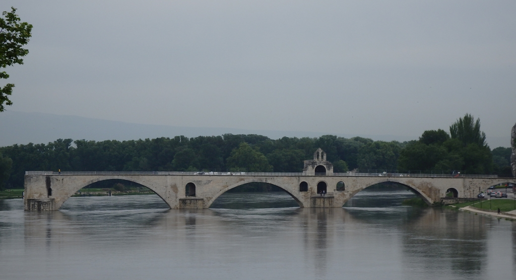
This was first built between 1171 and 1185 after a shepherd, Benezet had a vision and convinced the locals that God wanted this done. It was a very difficult task as the Rhone river is very wide and strong here so miracles were needed. It initially was only big enough for pedestrians and horses but is was still the only bridge over the Rhone south of Lyon for centuries. There was a toll that maintained the bridge and the hospice for travellers and pilgrims. It was damaged many times by floods and wars but an especially awful flood in 1668 left only 4 of the original 22 arches remaining. The next bridge was built in the 1800s.
Yes another aqueducto - but a big one. It is part of the 50 km long Nimes aqueduct which while mostly underground required a large bridge to cross the Gardon River. It is the highest of all the Roman aqueducts (nearly 50m tall) and as the water crossed the bridge it dropped a mere 2.5 cm. In fact in the whole 50 km to Nimes, the drop was was only 17m. After the Romans left it fell into disrepair but the lower tier continued to be used as a toll bridge for centuries. The Camargue is the delta of the Rhone as it enters the Mediterranean Sea. It is 40 km wide and is 2 m above sea level with marshy ground and lakes including the large Etang de Vaccares. A sea dike, Dique a la Mer, was built in the late 1859 to prevent the twice yearly sea water incursions and therefore enable agriculture. Levee walls were also built along the sides of the Rhone. The main activities are the National Park with its pink flamingoes, wild bulls, boars and white horses, as well as salt production and rice growing. This is the largest breeding colony of France of the greater flamingos. They live up to 50 years, become pink at about 5 years and move regularly around the Mediterranean Sea throughout their life. Arles is an ancient city. The Romans built the first bridge here over the Rhone river so it was a key stop on the road from Italy to Spain with the usual magnificent Roman buildings from circa 100BC, and then continued as a major trading centre until the 17th century. So it has Roman ruins, a medieval cathedral that crowned Emperors of the Holy Roman Empire and its last claim to fame is scenes from many paintings by Vincent Van Gogh. He lived here from 1888 to 1890 and painted hundreds of paintings. The tourist office has set up easels of his works at spots around town to help us find them. SCENES OF THE TOWN VINCENT MORE ROMANS St TROPHIME CHURCH Travelled south to see the circular lock further down the Canal Du Midi. The Canal du Midi (Occitan: Canal de las Doas Mars, meaning canal of the two seas) is a canal in Southern France constructed between 1666 and 1681. It was considered at the time to be one of the greatest construction works of the 17th century and is one the oldest canals of Europe still in operation. Essentially (with the involvement of navigable rivers) it joins the Atlantic Ocean and Mediterranean Sea. The main purpose at the time was to create a direct passage between the Mediterranean Sea and the Atlantic without passing through the Strait of Gibraltar controlled by the Spaniards. Interesting points . . . - the second ever large scale water reservoir was built to supply water to the canal as it crosses the continental divide - workers were paid loyalty bonuses, paid sick leave, non-working rain days, public hols & Sundays off - the problems of channels and lifting water were essentially solved by female workers who came from the Pyrenees who knew and still used the old Roman techniques of water supply. - commercial freight traffic only ceased in the 1970s - it is closed in winter to allow for maintenance - it also provides water to irrigate 40,000 hectares of farming land - at the busiest lock now there are over 10,000 tourist boat passages per season The Romans fortified this hilltop around 100 BC and it was later taken over by the Visigoths in the fifth century who founded the city and added to the fortifications. The Counts of Carcasonne then held out for generations against the French until the early 1200s when, with the help of the Pope's armies, Carcasonne was overrun. The fortified city now consists essentially of a concentric design with two outer walls with 53 towers and barbicans to prevent attack by siege engines. The castle inside possesses its own drawbridge and ditch leading to a central keep. By Napoleon's time the castle was no longer of military importance, had fallen into disrepair and was to be demolished. Local uproar resulted in renovation with a few additions ie turrets and crenellations. A Basque village and port on the south coast of France a few KM from the Spanish border. Noted for fishing especially anchovies and tuna. Originally the fisherman went as far as Newfoundland for cod and also the Basque Corsairs of the 17th century. In 1660 Louis XIV of France married Marie Theresa - the Infanta of Spain in the village Cathedral chosen as it was half way between Paris and Madrid. Became a resort after sea walls were constructed. Over 40% of the apartments in the town are holiday homes and only occupied for a few months each year. Camped in the aire immediately beside the railway station!
Village in the Poiteven marsh - Maraise Poiteven - commonly known as Venice Verte due to the green duck weed on the canal surface. The marsh was drain with the help of Dutch canal builders and is now a maze of islets criss-crossed by picturesque canals with isolated houses, villages and few roads. Main transport is flat-bottomed boats. We saw otters as we cycled the pathways beside the canal.
Town with a large collection of megalithic stones spread across the countryside. More than 300 stones in 3 major groups. Stones hewn from local rock and probably erected 3300 BC or earlier which makes them 1000 years older than Stonehenge. Up to 4M tall and run parallel in up to eleven rows.
|